


Tajima Mihonoura Course
但馬御火浦(みほのうら)コース
 |
 |
 |
 |
Route map
Route directions and land marks
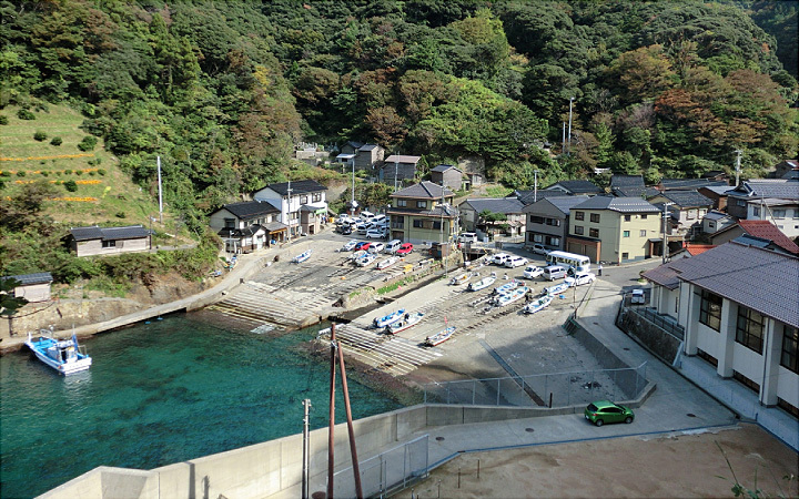
The village of "Mio" is situated in the cove of Riasu Coast, the area has numerous enduring legends and beautiful natural scenery. Located in the center of the San'in Kaigan UNESCO Global Geopark. Although you can enjoy the scenery from the seashore roads, we truly recommend you to take an excursion boat or water taxi to enjoy the scenery from the sea too.
- 1) Komio bus stop
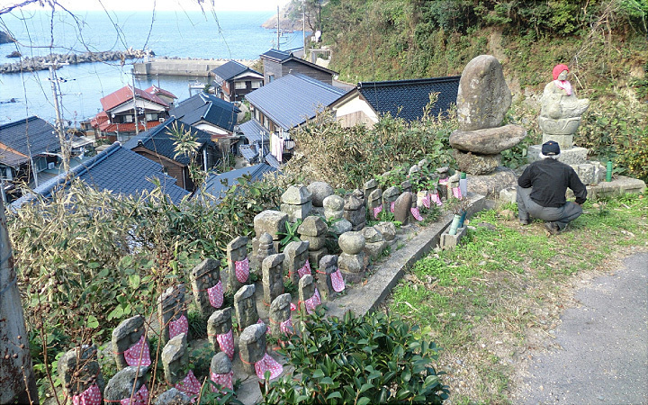
- If you take the town bus to Komio bus stop, you will find the stone Buddha statues of Komio. The statues were washed away into the sea in a landslide sometime in the Edo period (1603-1868), villagers were able to find 48 of the jizo (stone Buddha of the bodhisattva who looks over children, travellers and the underworld).
- 2) New Mio Tunnel
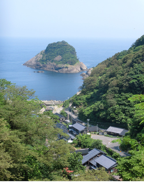
- When you walk up the road about 1km, there are two consecutive tunnels; the former Mio Tunnel completed in 1962 and the new Mio Tunnel completed in 1982. Looking back from the tunnels to the seaside you will see a magnificent landscape before you with Mio Oshima Island.
- 3) Mihashira Shrine
- Go back about 700m, as the road curves left there will be another narrow road that leads to Komio town. On your left will be Mihashira Shrine. As you approach the shrine you will see strange patterns on the volcanic rock at the foot of the torii gate. There are also ema (votive pictures) of people, animals, and birds and flowers on the ceiling of the front shrine and ones of dragons in the shrine's passage.
- 4) Fishing port and Magma path "dikes"
- Follow the stone steps down to the small fishing port, from the observatory park next to the intersection past the top of the hill you can look out over the scenery around Mio Oshima Island. From here you can also see the magma path "dikes" which was made when it opened up to the Sea of Japan.
- 5) Kageiwa Inari
- Near the mountains of the observatory park, if you climb the steep slope you will be able to see the shrine "Kageiwa Inari" which is made of cypress and is set inside a cave.
- 6) Fork in the road and Miihonoura assembly hall
- Head down from the observatory park and enjoy the Japan Sea's scenery on your left as you continue towards the town, you can get to the town by turning left at the junction of the three roads.
- 7) Nagasakibana
- When you see the port of Omio, pass in front of the Mihonoura assembly hall, and follow the coast along the promenade until you arrive at "Nagasakibana". Please watch your footing as the boardwalk is narrow and there is a steep drop off on the seaside. Nagasakibana is the closest to Mio Oshima island, from here you can see the beautiful rhyolite rocks with columnar joints. On the far side of the island is Itsukushima Shrine, it is believed to be a shrine for the god of safe sailing or sea voyage.
- 8) Yahashira Shrine
- Return to the port, turn left along the waterway into town, climb the more than 100 stone stop stairs up to Yahashira Shrine, a shrine to Omio's guardian god.
If you are taking the short course, return to Mio bus stop from here. This marks the end of the short course. (About 3km)
- 9) Observation deck overlooking Nokogirimisaki Cape
- Go up the road that goes through Mio town walking along the water, turn left at the three-way road. After walking for about 1.5 km on the right hand side, you will find the "spring of eternal life" springing from the cracks in the bedrock. You have arrived at the observation deck where you can see Nokogirimisaki Cape and Shitaaradoumon Sea Cave. Take a moment to enjoy this scenic spot with famous views of Tajima Mihonoura.
This marks the end of the long course; take the road back to Mio bus stop.
- Route
- Town bus Komio bus stop > Komio stone Buddha > Tunnel and Mio scenery > Mihashira Shrine > Observatory park > Kageiwa Inari shrine > Nagasakibana and Ebisu Shrine > Yahashira Shrine (>Spring of eternal youth > observation deck) > Town bus Mio bus stop
- Difficulty
-
Short course: ★☆☆ Long course: ★★☆
- Route Category
- Seaside
- Type of Activity


★☆☆ Flat course(Elevation gain less than 100m)or less than 5km.
★★☆ Slightly undulating course(Elevation gain less than 500m)or less than 10km.
★★★ Rugged course(Elevation gain more than 500m)or 11km.
★★☆ Slightly undulating course(Elevation gain less than 500m)or less than 10km.
★★★ Rugged course(Elevation gain more than 500m)or 11km.
| Distance | About 11km (the short course is about 3km) |
|---|---|
| Required Time | Walking time of about 3 hours, 1 hour for the short course |
| Starting Point | Start point: Town bus Mio bus stop End point: Town bus Mio bus stop |
| Getting Here | By Bus: Take the town bus to Komio bus stop. *The town bus does not run on Saturdays, Sundays and holidays. There are also few buses running during the week. Getting here by car is considered more convenient. By Car: Mio shop parking lot |
| Road Conditions | Asphalt |
| Resting Place | Public restroom: None Other restroom (during regular opening hours): Mihonoura Community Center, Mihonoura Assembly Hall Rest area: Some benches Shops: None |
| Signpost Presence | None |
| Guide Availability | Available Send guide request to: Shinonsen Town Office Commerce and Industry Tourism Division Phone: 0796-82-5625 Fee/charge : From JPY3,000 (depends on times and number of people) |
| Notes | There are rocky areas along the course so sports shoes should be worn. |
| Contact | Contact: Shinonsen Town Office Commerce and Industry Tourism Division Phone: 0796-82-5625 |
 |
- Kinki Long-Distance Nature Trail - Mt. Taishi hiking course
- Nekozaki Peninsula Hiking Course
- Walk around Takeda Castle ruins and Teramachi Street
- The Famous Scenic "Kasumi Kaigan" Shiokaze Course
- Visit one of Japan's 100 most secluded regions, Torokawa Valley and Mt. Torokawa mountain trail.
- Mt. Sobu & Mt. Oosugii to Oonuka Mountain Trail
- Walking Hamasaka Town
- Yumura Onsen Course
- Moroyose Course
- Ueyama Highlands Course
- Tajima Mihonoura Course
- Home of Silkworm Culture - Osugi & Kuragaki Route
- Mining Town Walking Course in Akenobe
- View from Above the Sea of Japan - Aerial Train- Course
- Exploration of History Through Muraoka Castle Town
- Hachikita Kogen Scenic Walking Course
- Japan’s Most Beautiful Village - Tour Kami Town Ojiro & Kusube Valley Falls
- Japan’s Most Beautiful Village - Kami Town Ojiro, Giant Tree Forest, Yoshitaki Falls
- Walk Around Kuchiganaya in Ikuno Town
- Uduka History Course - Legend of the Rabbit Burial Mounds
- Uwano Nature & Interaction Forest Course
- Highland Course of a Shimmering Starry Forest and Pond
- See Oriental White Storks Dance in the Sky
- Walk the Town Where Oishi Riku Once Lived
- Along the Road Kinosaki Where Shiga Naoya Walked
- Blessings of the Earth, Walk Through the Town of Kawaminato
- Kannabe lava flow and crater course in a town where the world adventurer Uemura Naomi was born.
- A Course Through Serene Rural Landscape and a Rice Ball
- Japanese Heritage and Kitamae Ship Port "Moroyose Port" Course (Moroyose Short Course)


