


Walking Hamasaka Town
浜坂まち歩き
 |
 |
 |
 |
Route map
Route directions and land marks
Enjoy the history of the old townscape along the Ajiwara Stream and the maze like "Fisherman Town". See beautiful panoramic views of the Sea of Japan and stretches of sandy beaches dotted with pine trees, all here in the town of Hamasaka that was developed on a sandbank.
- 1) Machi Aruki Information Center "Shouraian"
- The starting and end point is "JR Hamasaka Station" with its noren curtain. The station opened in 1898 and flourished as a railway base, the remnant water tower is discernible landmark. Here you will find the railway museum corner "Room of Tetsuko". In front of the station is the Machi Aruki Information Center "Shouraian" where you can get a map and check the route.
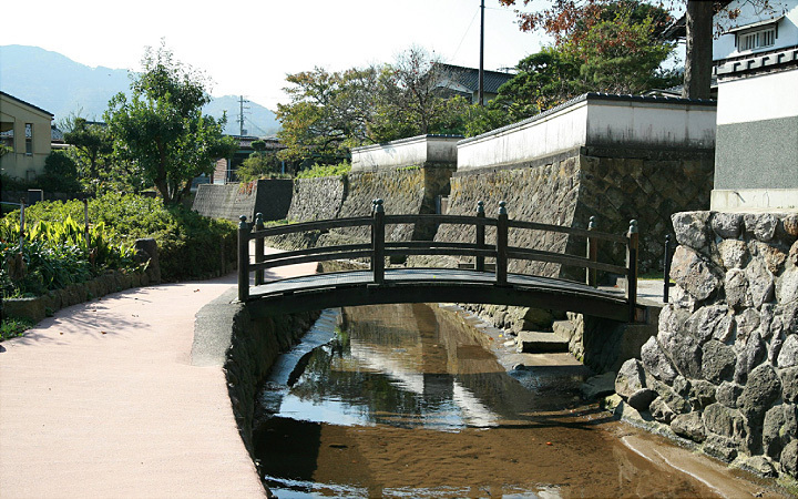
- 2) Ajiwara path
- Go straight out from the station, turn right at the intersection with the traffic lights, and turn left at the alley heading to the post office and you will come to a small river. This is Ajiwara River, go down the reddish-brown colored path. Flatboats use to travel up and down the river here; even now the stonewalls here from various time periods create a stunning landscape. Wells and washing stations can also be found along the river, festivals are held around here celebrating the god of water and Kannon (god or goddess of mercy). Ajiwara path is a well-known area on the course.
- 3) Buntaro Kato Memorial Library
- Continue along and you will see "Buntaro Kato Memorial Library", which is modeled after a mountain, on your right. Information on Buntaro Kato, a solitary climber from Hamasaka, is displayed on the second floor.
Cross the bridge on the left past the library and go up the stone paved slope, on the right is a well / washing station and Saikoji Temple, on the left is the Imeitei Museum (Museum of local great figures) which has been refurbished in the former Mori family home. By all means, feel free to come in and look around.
- 4) Imeitei Museum (Museum of local great figures)
- Leave the Imeitei Museum (Museum of local great figures) and go to the right, at the end of road is "Utopia Hamasaka" Public Bathhouse. Here there is a hot water basin you can make your own Onsen Tamago (hard boil an egg in hot spring water) in. Leave from Utopia Hamasaka and go down to the left, immediately on your right is a hot spring source, you can see hot spring water flowing out. The hot spring water is distributed to all the houses in the area; the water is extremely hot and can burn you so please be careful.
Return to the Ajiwara path and follow it to the north to harbor, you will see Hamasaka's old fishing port. The large stone lantern resembles the old lighthouse.
- 5) Temple of "Ryugu-sama"
- Traveling away from Ajiwara path, going further north on the paved road along the river, you can see the Sea of Japan in front. In the winter surging waves surge back up the river. If you turn right and you can get close to the sea, but we will go straight. Go a little ways up the incline in the road and you will find the temple of "Ryugu-sama" the god that protects the safety of the sea. The area nearby is referred to as "Fisherman Town", the roads here are narrow and complex, and walking here feels almost like entering a maze. If you have the time try exploring the streets.
- 6) Hamasaka Beach (Hamasaka prefectural sun beach)
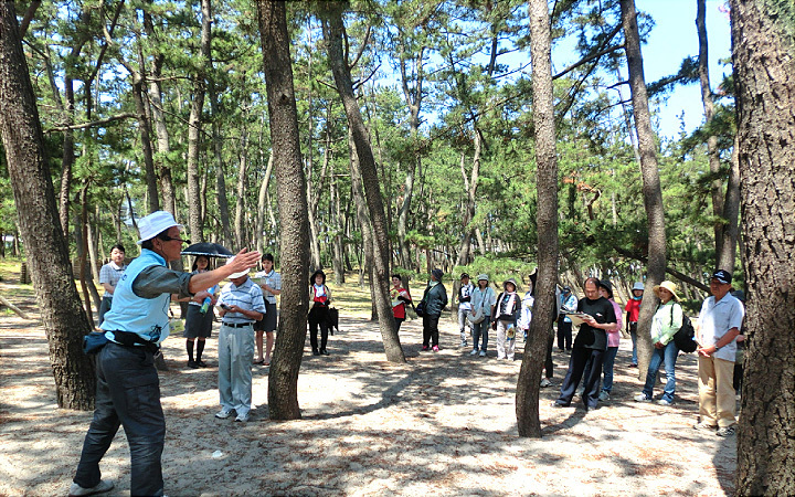
- Go to the west from Ryugu-sama with the Sea of Japan on your right, you will see a pine forest on the left. Originally, the Hamasaka coast was covered in wide sand dunes, but in early Showa period pine trees were planted to create a windbreak and to control erosion. Today it is one of Japan's 100 chosen "Hakusa-seisho", a beautiful stretch of sandy beach dotted with pine trees, making it a great walking course. There is a maintained boardwalk along Hamasaka Beach (Hamasaka prefectural sun beach) that makes for a lovely walk. At the end of the boardwalk is the San'in Kaigan Geopark Center. Here you can learn about the dramatic birth of the Sea of Japan.
- 7) Shiokaze Street
- Leave the geopark center and go along the pine forest directly outside, turn left at the intersection with the traffic light, then turn right at the sign for Shiokaze Street and go straight. You should soon see a cemetery (the tombs of Soubei Ichihara, who played an important part in promoting Hamasaka needles as a past major industry; and Buntaro Kato the mountain climber are here) and an office on the left. Continue until the end of the street then turn left. You should then be able to see the JR San'in line train tracks.
- 8) JR Hamasaka Station
- Continue straight ahead until you return to JR Hamasaka Station. You can rest and soak your feet in the footbath at the station; you can also take a listen to the Hamasaka needle on the gramophone at Machi Aruki Information Center. The shops in front of the station also sell fun souvenirs like Hamasaka grilled chikuwa.
- Route
- JR Hamasaka Station (Room of Tetsuko Museum (Railway museum corner)) > Machi Aruki Information Center > Ajiwara Path > Buntaro Kato Memorial Library > Imeitei Museum (Museum of local great figures) > Utopia Hamasaka > Source of a hot spring > Funa tamari > Ryugu-sama > Hamasaka prefectural sun beach (Garden of pine) > San'in Kaigan Geopark Center > (Tajima coast pleasure boat / Seafood market) > Souvenir market > JR Hamasaka Station
- Difficulty
- ★☆☆
- Route Category
- In Town
- Type of Activity


★☆☆ Flat course(Elevation gain less than 100m)or less than 5km.
★★☆ Slightly undulating course(Elevation gain less than 500m)or less than 10km.
★★★ Rugged course(Elevation gain more than 500m)or 11km.
★★☆ Slightly undulating course(Elevation gain less than 500m)or less than 10km.
★★★ Rugged course(Elevation gain more than 500m)or 11km.
| Distance | About 3km |
|---|---|
| Required Time | Walking time of about 2 hours (times do not include time needed to view the facilites,) Cycling time of about 1 hour. |
| Starting Point | JR Hamasaka Station (If coming by car, Buntaro Kato Memorial Library as well as Hamasaka prefecture sun beach) |
| Getting Here | By Train: JR Hamasaka Station By Car: Buntaro Kato Memorial Library as well as Hamasaka prefecture sun beach |
| Road Conditions | Asphalt |
| Resting Place | Public restroom: JR Hamasaka Station, Hamasaka pocket park, Matsu no Niwa (Garden of pine) restroom, Buntaro Kato Memorial Library, Imeitei Museum (Museum of local great figures), San'in Kaigan Geopark Center Rest area: Machi Aruki Information Center, Station footbath, Hamasaka pocket park Shops: Yoneda Shop(lunch bread), Nakake (super market), Marukai Watanabe Fishery (restaurant, souvenirs), Yonetora Shop (grilled chikuwa;tube-shaped fish-paste cake), Matsuoka Tsukimido, Shinkine (Wagashi (Japanese sweets)), Utopia Hamasaka, Matsu no Yu (public hot spring bathhouse), etc. |
| Signpost Presence | Yes |
| Guide Availability | Available Send guide request to: Machi Aruki Information Center, Shouraian Phone: 0796-80-1126 Fee/charge: From JPY 3,000 (depends on time and number of people) |
| Contact | Contact: Machi Aruki Information Center Phone: 0796-80-1126 |
 |
- Kinki Long-Distance Nature Trail - Mt. Taishi hiking course
- Nekozaki Peninsula Hiking Course
- Walk around Takeda Castle ruins and Teramachi Street
- The Famous Scenic "Kasumi Kaigan" Shiokaze Course
- Visit one of Japan's 100 most secluded regions, Torokawa Valley and Mt. Torokawa mountain trail.
- Mt. Sobu & Mt. Oosugii to Oonuka Mountain Trail
- Walking Hamasaka Town
- Yumura Onsen Course
- Moroyose Course
- Ueyama Highlands Course
- Tajima Mihonoura Course
- Home of Silkworm Culture - Osugi & Kuragaki Route
- Mining Town Walking Course in Akenobe
- View from Above the Sea of Japan - Aerial Train- Course
- Exploration of History Through Muraoka Castle Town
- Hachikita Kogen Scenic Walking Course
- Japan’s Most Beautiful Village - Tour Kami Town Ojiro & Kusube Valley Falls
- Japan’s Most Beautiful Village - Kami Town Ojiro, Giant Tree Forest, Yoshitaki Falls
- Walk Around Kuchiganaya in Ikuno Town
- Uduka History Course - Legend of the Rabbit Burial Mounds
- Uwano Nature & Interaction Forest Course
- Highland Course of a Shimmering Starry Forest and Pond
- See Oriental White Storks Dance in the Sky
- Walk the Town Where Oishi Riku Once Lived
- Along the Road Kinosaki Where Shiga Naoya Walked
- Blessings of the Earth, Walk Through the Town of Kawaminato
- Kannabe lava flow and crater course in a town where the world adventurer Uemura Naomi was born.
- A Course Through Serene Rural Landscape and a Rice Ball
- Japanese Heritage and Kitamae Ship Port "Moroyose Port" Course (Moroyose Short Course)