


Mt. Sobu & Mt. Oosugii to Oonuka Mountain Trail
蘇武岳・大杉山~大糠登山道
 |
 |
 |
Route map
Route directions and land marks
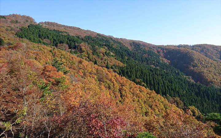
It was common practice during the early Showa era (mid 1900's) to form a party of two or more when mountain climbing. However, the climber Buntaro Kato successively climbed and conquered the Japanese Alps solo as well as Naomi Uemura who became internationally famous for traveling the 7 continents to climb the world's highest peaks solo. They were both in love with Mt. Sobu. Enjoy Tajima's great outdoors by taking the same trail as them through beech forests up to the top of Mt. Sobu for a 360 degree panoramic view of the Sea of Japan and Mt. Hyonosen. For this course we recommend using a guide because of the long distance over varying elevations and the time that it will take to complete the course.
- 1) Manba Ski Resort
- From the Manba Ski Resort parking lot walk for about 20 minutes up the work roads of the ski slopes, you will see a signboard for the starting point of Manba Trail.
- 2) Oosugi Mountain Course
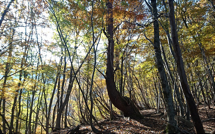
- From there, continue for another 20 minutes, you will come to a fork in the road for "Kyojyu no Tani Course " and "Oosugi Mountain Course". Proceed to the right. Most of the course is through virgin forest and beautiful beech forest until you reach the summit.
- 3) Oosugi
- After about 2 hours of walking, you will see large cedar trees that gave the mountain its name Mt. Oosugi (Japanese for large cedar) and will soon arrive at Mt. Oosugi (elev. 1,007m).
- 4) Kyojyu no Tani Course
- As you continue forward you will cross over a mountain ridge called Four Mountain Crossings. Walk for another about another 50 minutes and we will merge with the mountain trail "Kyojyu no Tani Course" that we passed at the fork earlier.
- 5) Mt. Sobu
- Walk for about 40 minutes before reaching Mt. Sobu (elev. 1,074m).
When you arrive at Mt. Sobu you will be able to see over the many mountains of the Chugoku region including: the highest peak of Hyogo Prefecture Mt. Hyonosen to the west, Mt. Hachibuse famous for Hachikita Ski Area (elev. 1,221m), and Mt. Ouginosen (elev. 1,310m) among others. Also, the Sea of Japan spreads out to the north and the Toyooka Basin to the east creating a magnificent 360-degree panoramic view.
- 6) Sobu observation deck
- When you go about 30 minutes down Mt. Sobu, you will arrive at the Sobu observation deck. This is also connected to the wide-area forest road and is used by many people to come up by car.
- 7) Goal
- There is a lower mountain road beside the observation deck. When you walk back down the mountain for about 10 minutes you will see a fork in the road branching off for a trail to Teragauchi and one from Oonuka Trail, go to the right (Oonuka trail 大糠) and continue your climb down. After about 2 hours you will pass through Oonuka Uma no Se and arrive at Oounaka trail's starting point on the Muraoka side.
Since this is a demanding hiking course, shoes suitable for mountain trekking such as durable trekking shoes are highly advisable. However, the road is fairly easy to walk on. You might want to consider going with an experienced mountaineer from Tajima.
- Route
- Kannabe Manba TenJinja Shrine > Kannabe mountain trail > Mt. Oosugi> Mt. Sobu > Mt. Sobu observation deck > Oonuka Uma no Se > Oonuka trailhead > Muraoka Farm Garden Roadside Rest Area
- Difficulty
- ★★★
- Route Category
- Mountain and highlands
- Type of Activity


★☆☆ Flat course(Elevation gain less than 100m)or less than 5km.
★★☆ Slightly undulating course(Elevation gain less than 500m)or less than 10km.
★★★ Rugged course(Elevation gain more than 500m)or 11km.
★★☆ Slightly undulating course(Elevation gain less than 500m)or less than 10km.
★★★ Rugged course(Elevation gain more than 500m)or 11km.
| Distance | About 12km |
|---|---|
| Required Time | Walking time of about 7 hours |
| Starting Point | Starting point: Kannabe Highlands Roadside Rest Area Ending point: Muraoka Farm Garden Roadside Rest Area |
| Getting Here | By Train / Bus: Take the Zentan Bus bound for Kannabe Highlands from JR Ebara Station, get off at Kannabe Yutorogi Onsen bus stop. Parking Lot: Kannabe Highlands Rest Area, Manba Ski Resort |
| Road Conditions | Dirt / Unpaved |
| Resting Place | Restroom: Kannabe Highlands Rest Area, Manba Ski Resort Manba Tenjinja Shrine, Muraoka Farm Garden Rest Area Rest Area: Mt. Sobu observation deck (no restroom) |
| Signpost Presence | Yes |
| Guide Availability | Available Send guide request to: Uduka no Mori Phone: 0796-96-0024 Fee/charge: JPY 3,500 |
| Notes | The trails are impassable during the winter. Shoes suitable for mountain hiking, such as trekking/hiking shoes are advisable. Portable restrooms are also suggested, as there are no restrooms along the way. It is also advisable to bring a lunch, water and such. |
| Contact | Contact: Uduka no Mori Phone: 0796-96-0024 |
 |
- Kinki Long-Distance Nature Trail - Mt. Taishi hiking course
- Nekozaki Peninsula Hiking Course
- Walk around Takeda Castle ruins and Teramachi Street
- The Famous Scenic "Kasumi Kaigan" Shiokaze Course
- Visit one of Japan's 100 most secluded regions, Torokawa Valley and Mt. Torokawa mountain trail.
- Mt. Sobu & Mt. Oosugii to Oonuka Mountain Trail
- Walking Hamasaka Town
- Yumura Onsen Course
- Moroyose Course
- Ueyama Highlands Course
- Tajima Mihonoura Course
- Home of Silkworm Culture - Osugi & Kuragaki Route
- Mining Town Walking Course in Akenobe
- View from Above the Sea of Japan - Aerial Train- Course
- Exploration of History Through Muraoka Castle Town
- Hachikita Kogen Scenic Walking Course
- Japan’s Most Beautiful Village - Tour Kami Town Ojiro & Kusube Valley Falls
- Japan’s Most Beautiful Village - Kami Town Ojiro, Giant Tree Forest, Yoshitaki Falls
- Walk Around Kuchiganaya in Ikuno Town
- Uduka History Course - Legend of the Rabbit Burial Mounds
- Uwano Nature & Interaction Forest Course
- Highland Course of a Shimmering Starry Forest and Pond
- See Oriental White Storks Dance in the Sky
- Walk the Town Where Oishi Riku Once Lived
- Along the Road Kinosaki Where Shiga Naoya Walked
- Blessings of the Earth, Walk Through the Town of Kawaminato
- Kannabe lava flow and crater course in a town where the world adventurer Uemura Naomi was born.
- A Course Through Serene Rural Landscape and a Rice Ball
- Japanese Heritage and Kitamae Ship Port "Moroyose Port" Course (Moroyose Short Course)


