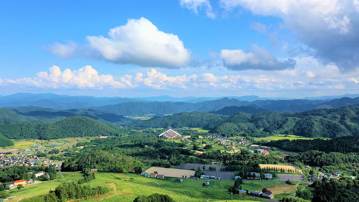
Kannabe lava flow and crater course in a town where the world adventurer Uemura Naomi was born.
神鍋溶岩流と噴火口コース -世界の冒険家植村直己が生まれた町-
 |
Some 22,000 years ago lava flowed from Mt. Kannabe's volcano, over several tens of thousands of years the hardened lava flow eroded and formed the Kannabe highlands. This course allows visitors to enjoy Kannabe year round.
Route map
Recommended Spots of Interest
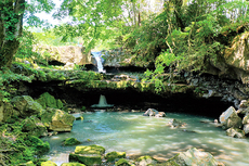
- 1) Nidan Falls
- In 2019, the waterfall's appearance changed when an anomaly created a 1 meter diameter pothole in the bedrock of the waterfall. The mossy rock is a beautiful waterfall.
- 2) Mabo
- Long ago there use to be a gold mine in Kannabe, it became known as "mabo (mine road)".
- 3) Hattan Falls
- This fall gets its name because the height of the fall (24m) is equivalent to the Japanese length of an eight cloth or 'nuno hattan'. This is the largest waterfall along Kannabe's old lava flow.
- 4) Tajima Dome
- An all-weather dome facility has become a landmark of Kannabe and hosts sporting events and training camps.
- 5) Monument to the origin of Kannabe
- The monument was erected in 1983 in celebration of Kannabe's ski areas' 60th anniversary since they opened in 1923.
- 6) Kannabe Shrine
- Located at the summit of Mt. Kannabe, it is also called the 'three gods shrine' because of the three gods, god of fire, god of the mountain, and the god of beauty(landscape) are enshrined there.
- 7) Mt. Kannabe crater
- A power spot where you can feel the magnificence of nature in a volcano crater that is 750m in circumference and 50m deep.
- Route Starting Point and Destination
- Start: Kiyotaki community center
Destination: Roadside station Kannabe Kogen
- Difficulty
- ★★☆
- Type of Activity


★☆☆ Flat course(Elevation gain less than 100m)or less than 5km.
★★☆ Slightly undulating course(Elevation gain less than 500m)or less than 10km.
★★★ Rugged course(Elevation gain more than 500m)or 11km.
★★☆ Slightly undulating course(Elevation gain less than 500m)or less than 10km.
★★★ Rugged course(Elevation gain more than 500m)or 11km.
| Distance | About 6.5km |
|---|---|
| Required Time | Walking time of about 4.5 hours. |
| Start & Destination | Start: Kiyotaki community center Destination: Roadside station Kannabe Kogen |
| Getting Here | By Train: Take JR train to Ebara Station, then board the Zentan Bus for Tochimoto bus stop. By Car: Park at Kiyotaki Community Center |
| Road Conditions | Asphalt & dirt |
| Signpost Presence | None |
| Contact | Contact: Hidaka Kannabe Tourism Association Phone: 0796-45-0800 |
- Kinki Long-Distance Nature Trail - Mt. Taishi hiking course
- Nekozaki Peninsula Hiking Course
- Walk around Takeda Castle ruins and Teramachi Street
- The Famous Scenic "Kasumi Kaigan" Shiokaze Course
- Visit one of Japan's 100 most secluded regions, Torokawa Valley and Mt. Torokawa mountain trail.
- Mt. Sobu & Mt. Oosugii to Oonuka Mountain Trail
- Walking Hamasaka Town
- Yumura Onsen Course
- Moroyose Course
- Ueyama Highlands Course
- Tajima Mihonoura Course
- Home of Silkworm Culture - Osugi & Kuragaki Route
- Mining Town Walking Course in Akenobe
- View from Above the Sea of Japan - Aerial Train- Course
- Exploration of History Through Muraoka Castle Town
- Hachikita Kogen Scenic Walking Course
- Japan’s Most Beautiful Village - Tour Kami Town Ojiro & Kusube Valley Falls
- Japan’s Most Beautiful Village - Kami Town Ojiro, Giant Tree Forest, Yoshitaki Falls
- Walk Around Kuchiganaya in Ikuno Town
- Uduka History Course - Legend of the Rabbit Burial Mounds
- Uwano Nature & Interaction Forest Course
- Highland Course of a Shimmering Starry Forest and Pond
- See Oriental White Storks Dance in the Sky
- Walk the Town Where Oishi Riku Once Lived
- Along the Road Kinosaki Where Shiga Naoya Walked
- Blessings of the Earth, Walk Through the Town of Kawaminato
- Kannabe lava flow and crater course in a town where the world adventurer Uemura Naomi was born.
- A Course Through Serene Rural Landscape and a Rice Ball
- Japanese Heritage and Kitamae Ship Port "Moroyose Port" Course (Moroyose Short Course)


