Nekozaki Peninsula Hiking Course
猫崎半島ハイキングコース
 |
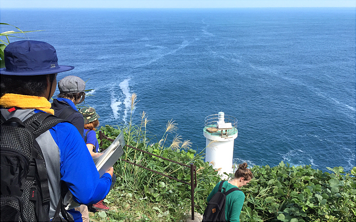
At the tip of the peninsula is a lighthouse. Enjoy a hike out to the Nekozaki Lighthouse at the end of the peninsula. At the tip you will have an expansive 270-degree view out over the Sea of Japan and the coast. You will come across many interesting scenes along the hike including potholes (giant's kettle) eroded by waves on the peninsula's west side and fossil footprints of shells and elephants.
Route map
Route directions and land marks
- 1) Takeno Kodomo Taiken Mura
- Walking west from Takeno Kodomo Taikenmura head for Nekozaki Peninsula. Nekozaki Peninsula is said to look like a crouching cat from off shore. The locals are also familiar with the peninsula's nickname "Kewpie Peninsula" because it looks like a kewpie doll from the coastal roads.
- 2) Takeno Hama Beach
- Along the road "Takeno Hama Beach" extends out, the beach was chosen as one of Japan's top 100 swimming beaches and national site of scenic beauty. To get to Nekozaki Peninsula, walk to the Gosha parking lot along the sandy coastline that stretches for 800m east to west. Currently, the mouth of Takeno River near here is a fishing port, but during the Edo period it was also the windward waiting port for cargo ships wanting to avoid storms. The east side of the peninsula provided cover from northwest seasonal wind and is still used as a windward waiting fishing port for ships today.
- 3) Gosha parking lot
- Pass through the Gosha parking lot, after about 100m you will arrive at the west side entrance to the peninsula. From here you can walk along the seacoast on the west side, walk on the rocky beach. Because the rocks can be wet and covered in seaweed in places you should pay close attention to where you walk and your footing so as not to slip.
- 4) Giant's kettles carved into the coastal bench
- Continue along and you will see "giant's kettles (potholes)" that were carved into the coastal bench by raging waves from The Sea of Japan. These giant's kettles are designated as natural treasures in Hyogo prefecture. If you continue down further you will see fossilized footprints of elephants, deer and stefolophodon who inhabited the Asian continent about 20 million years ago on the coastal bench.
- 5) Paved path
- Further ahead along the coast there is a paved path, you may see garbage and debris washed up on shore that has drifted from Korea, China, Russia and other neighboring countries.
- 6) Stairs
- As you walk along the western side of the coast, you will see the first set of stairs on the right. Climb the stairs to get to the entrance of Nekozaki Peninsula. This will be the last place with a restroom. There is only one trail from the entrance to the goal point at the lighthouse on the tip of the peninsula. The course you'll walk along is an intermediate mountain course.
- 7) Kashima Park
- From the entrance point the path is paved with a gentle incline, after about 10 minutes you will arrive at "Kashima Park". There are benches in the park to rest on. In the summer you can enjoy sunrises and sunsets over the sea. The path past the park becomes a nature trail; here you will find a number of "Ojizo-sama (bodhisattva statues who look over children, travellers and the underworld)." The statues were donated by local boatmen in 1917 and are connected to the "88 hallowed grounds of Shikoku". There are 87 on Nekozaki Peninsula for those who cannot make a pilgrimage to far away Shikoku. The 88th is dedicated to the Rukaiji Temple grounds in the town of Takeno.
- 8) Oku no In
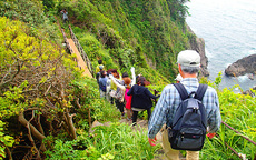
- Continuing on you will find "Oku no In" where the last Ojizo-sama is placed. The road from "Oku no In" to the summit will take about 20 minutes, but from here the slop of the trail becomes extreme and there will be stone stairs to climb so trekking shoes, hat, towel and beverages are needed.
- 9) Stone stairs
- After taking a break at the summit (elev. 141.4m), continue down the stone stairs. The steep slope on this side is also extreme so it is important that you take your time and climb down slowly and carefully.
- 10) Cracked stratum "Ryumongan (rhyolite)"
- When you go down the slope from the summit you will see a bridge. From this bridge that hangs about 80m above sea level, you can see spectacular views of the Japan Sea and rocks of cracked stratum "Ryumongan (rhyolite)" extending perpendicularly to the Nekozaki Peninsula cliff. These are thought to be from lava flowing on top of the raised stratum that accumulated in the water around 18 million years ago. It is also a great place to take photos.
- 11) Nekozaki Lighthouse
- If you walk for about another 5 minutes past the bridge, you will arrive at the northern most point of Hyogo Prefecture and the goal point for this course, "Nekozaki Lighthouse". Here is a fantastic panoramic view of the Sea of Japan, sweeping 270 degrees from the most northern part of the Kinki region "Tango Peninsula Kyogamisaki Cape" in the east to Kami Town's "Isasa Misaki Cape" in the west.
- Route
- JR Takeno station > Zentan Bus (Takeno Kaigan Line) >Takeno Hama Bus stop> Walk (10min) > Nekozaki Peninsula trailhead
- Difficulty
- ★★☆
- Route Category
- Mountain
- Type of Activity


★☆☆ Flat course(Elevation gain less than 100m)or less than 5km.
★★☆ Slightly undulating course(Elevation gain less than 500m)or less than 10km.
★★★ Rugged course(Elevation gain more than 500m)or 11km.
★★☆ Slightly undulating course(Elevation gain less than 500m)or less than 10km.
★★★ Rugged course(Elevation gain more than 500m)or 11km.
| Distance | One way is about 2.3km. Round trip is about 4.6km. Summit 141.4m. |
|---|---|
| Required Time | Walking time of about 2 hours. |
| Starting Point | Takeno Kodomo Taikenmura |
| Getting Here | By Train / Bus: JR Takeno station > Zentan Bus (Takeno Kaigan Line) > Takeno Hama Bus stop> Walk (5min) > "Takeno Kodomo Taikenmura" parking lot By Car: Drive to Takeno Kodomo Taikenmura parking lot |
| Road Conditions | Dirt / Stone stairs |
| Resting Place | Kitamaekan (restroom, hot spring bath, restaurant) Gosha parking lot (drink vending machine, restroom) Nekozaki Peninsula base (restroom) Kashima Park (bench, sunrise & sunset view points) Nekozaki summit (rest area) Nekozaki lighthouse (observation deck) |
| Signpost Presence | Yes |
| Guide Availability | Available Send guide request to: Takeno Kodomo Taikenmura Phone: 0796-47-1080 Fee/charge : JPY600(+tax)/person (min of 3 people) |
| Contact | Contact: Takeno Tourism Association Phone: 0796-47-1080 |
- Kinki Long-Distance Nature Trail - Mt. Taishi hiking course
- Nekozaki Peninsula Hiking Course
- Walk around Takeda Castle ruins and Teramachi Street
- The Famous Scenic "Kasumi Kaigan" Shiokaze Course
- Visit one of Japan's 100 most secluded regions, Torokawa Valley and Mt. Torokawa mountain trail.
- Mt. Sobu & Mt. Oosugii to Oonuka Mountain Trail
- Walking Hamasaka Town
- Yumura Onsen Course
- Moroyose Course
- Ueyama Highlands Course
- Tajima Mihonoura Course
- Home of Silkworm Culture - Osugi & Kuragaki Route
- Mining Town Walking Course in Akenobe
- View from Above the Sea of Japan - Aerial Train- Course
- Exploration of History Through Muraoka Castle Town
- Hachikita Kogen Scenic Walking Course
- Japan’s Most Beautiful Village - Tour Kami Town Ojiro & Kusube Valley Falls
- Japan’s Most Beautiful Village - Kami Town Ojiro, Giant Tree Forest, Yoshitaki Falls
- Walk Around Kuchiganaya in Ikuno Town
- Uduka History Course - Legend of the Rabbit Burial Mounds
- Uwano Nature & Interaction Forest Course
- Highland Course of a Shimmering Starry Forest and Pond
- See Oriental White Storks Dance in the Sky
- Walk the Town Where Oishi Riku Once Lived
- Along the Road Kinosaki Where Shiga Naoya Walked
- Blessings of the Earth, Walk Through the Town of Kawaminato
- Kannabe lava flow and crater course in a town where the world adventurer Uemura Naomi was born.
- A Course Through Serene Rural Landscape and a Rice Ball
- Japanese Heritage and Kitamae Ship Port "Moroyose Port" Course (Moroyose Short Course)


